New firebreak shields valley

The following article first appeared on the front page of the Wednesday, May 1, 1963 edition of “THE OJAI VALLEY NEWS”. It is reprinted here with their permission. The author is unknown.

TO PREVENT DISASTER

New firebreak shields valley

Ojai was partially swept by a brush fire in the 30’s and again in 1948. A project aimed at preventing repetition of such disasters is now underway in the mountains along the city’s northern boundary.

The project is a firebreak—or fuelbreak, as it is called by the U.S. forest service—to check any fires which might threaten the city.

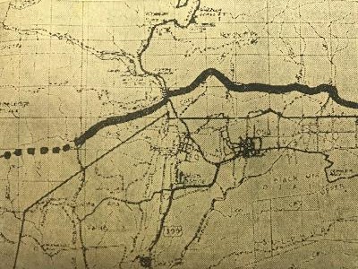
When completed, the fuelbreak will extend all the way across the county from the Santa Barbara to the Los Angeles county lines. A 16-mile section of the break from Santa Ana canyon, across highway 399 to the Topa Topa bluffs already has been completed. This includes the portion directly north of the city of Ojai.

A second four-mile section from San Cayetano to the Sespe along the southern border of the Sespe wildlife area also has been completed.

Portions from Santa Ana canyon to the Santa Barbara line, from Topa Topa bluffs to San Cayetano and from the Sespe crossing to the Los Angeles county line are still incomplete but work is proceeding on these sections. When the project is complete, it will form a continuous fuelbreak about 60 miles long.

The break consists of a strip of land cleared of brush for a maximum width of 500 feet where the terrain permits and a minimum width of 200 feet. Once cleared of the heavy brush the strip is seeded to rye grass and blando brome grass, hardy and fast growing varieties which require a minimum of moisture.

The object is to have the grass take over, providing a good cover and a minimum of fuel for a fire crossing the strip. The project provides for a continuous program of maintenance of the break, which includes keeping down the brush after it is removed.

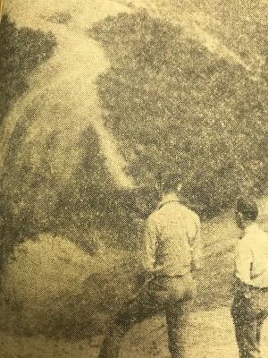
The work has been done by tractors and bulldozers in areas where these machines can work; in other areas such as canyons and gullies, the grubbing out has been done by men with hand tools.

The job has involved the gathering of large piles of brush. Some of this has been burned on favorable days. In other cases the brush has been shredded by tractors and worked into the soil of the fuelbreak.

The total area cleared is about 24 acres to a mile, but the brush has been cleared from about 384 acres in the 16 miles of fuelbreak already constructed.

North and east of Ojai many fingers and rectangles of privately owned land extend into Los Padres national forest, and in most cases north of the city the fuelbreak has been constructed across these lands. Forest service officials reported good cooperation from owners in getting their consent to build the break across their property. “We had to do some talking to get their consent in a few cases,” said Fred Bennett, Ojai district fire control officer, “but once they understood why we were doing it, and that it was for their own protection they were cooperative.”

The break has been constructed above the homes on these private lands to afford them the greatest protection. Another reason for crossing the private land was that the terrain becomes too steep to the north of these private holdings.

Chemical sprays and hand cutting will be the means used to keep down undesirable growth and permit the grass to take hold.

Deer have been of assistance in “maintaining” the break because they frequent the cleared area in considerable numbers and feed on the young shoots.

As part of the fire control program, water supplies in Gridley, Cozy Dell, Senior, Horn, Stewart and other canyons will be considered as available in case of need. It is also planned to develop other water storage together with access roads.

As an additional control factor, the fuelbreak has been planned to run as straight as possible considering the sometimes very rough terrain. Object of this is to allow borate bombers as straight runs as possible to spill their fire quenching chemical.

The project is a cooperative venture between the U.S. forest service and the county, with the county supplying the funds.

The break north of Ojai has been carefully planned to avoid a scar on the mountain which would be visible from the valley. The break in this area lies behind the geologic overturn—the row of small rounded hills which are such a conspicuous element of the northern view. The fuelbreak follows a swale or valley behind the hills and it cannot be seen from the valley except for a short distance at Gridley canyon and at highway 399.

FOREST SERVICE officials view portion of fuelbreak. This view is looking east from the head of Thacher canyon.
FUELBREAK to protect Ojai from forest fire is shown on this map. Solid line shows the portion of the 200 to 500-foot wide break which has been completed. Dotted line indicates the uncompleted portion. Map was drawn by Dean Price of U.S. forest service.


Reminiscences of Early Ojai (No. 4)

The following article was written by Howard Bald and appeared in the March 28, 1973 edition of the Ojai Valley News. It is reprinted here with their permission. Photos have been added by the Ojai Valley Museum. Bald used the same title for many of his articles. So the Ojai Valley Museum added “(No. 4)” to distinguish this particular article. 

Reminiscences of Early Ojai (No. 4)
by
Howard Bald

In 1898 the Santa Barbara National Forest (now Los Padres) was created with the headquarters in Nordhoff. Willis M. Slosson was sent out from the east as supervisor. The boundaries extended from Castaic up into San Luis Obispo county and north into Kern county.

This old residence on S. Signal Street was Ojai's original United States Forest Service headquarters when Ojai was still named Nordhoff. At present, S. Signal ends at the City of Ojai's public works yard. But, before the yard was there, S. Signal Street ran down the hill and connected with Creek Road.
This old residence on S. Signal Street might be Ojai’s original United States Forest Service headquarters when Ojai was still named Nordhoff. At present, S. Signal ends at the City of Ojai’s public works yard. Before the yard was there, S. Signal Street ran down the hill and connected with Creek Road.

Men were recruited from all parts of “back country,” and they were largely homesteaders, cowboys, miners and such. Their pay was $60 per month. They had to own at least two horses and maintain them. Generally the ranger (they were all rangers then) had to provide his own quarters. There were no fringe benefits.

With Nordhoff the national forest headquarters, and since the only means of getting about was via saddle and pack horses, there was a great deal of forestry activity in the valley, that is, mountain men coming and going. A more rugged, hardy, self-sufficient, picturesque group of men would be hard to imagine. Though as a whole they were rather short on formal education, they accomplished a prodigious amount in the way of trail building, and maintaining, investigating mines and homesteads, issuing grazing permits and performing fire suppression.

They were deputy and game commissioners.

Of course there were no telephones at first, no lookout stations, no airplanes or helicopters, or radios, and but few trails. Sometimes a ranger would ride a day or more to get to a fire. The nearest ranger to a fire might recruit a few men – homesteaders, cattlemen or miners, and with just a few simple tools attack the fire.

One wonders now how they accomplished so much with so few men and little equipment, when one hears of the hundreds of men, bombers, fire engines and other sophisticated equipment that is employed to suppress the same fires today -–and at a cost of hundreds of thousands of dollars.

Among some of the more colorful men of that period was Jacinto Reyes, who to this day is a legend among people in the back country, not only for his fire fighting but also for his horsemanship, endurance, rescue work and ability to settle sometimes violent disputes among homesteaders, cattlemen or miners. Then there were his brother Geraldo Reyes, Fred Ortega (father of ex-Ventura postmaster Melito Ortega) and Fred de la Riva. There were what we called in that day “California Spanish.” They were great horsemen and very capable.

Forest Rangers at a backcountry camp, circa 1906. Far right, Howard Bald; next to him is Jacinto Reyes, then Bob Clark. Others unidentified.

My father, George Bald, became one of them in 1903 and until the mid-twenties was chief ranger of this area. Trever Isenberg, Jerome Larmer, Bob Clark, Bob Miller, Bill Herbert, the Leiber brothers, Tom Dunsmore, Gene Johnson were among others of that day I remember. They were what one might call, at that time, “real westerners.”

George Bald (center).
George Bald, center. Others unidentified.

Sarah McMullen was a nurse who came to take care of Loring Farnum, a semi-invalid who bought our Rinconada ranch (J.D. Reyes and I gave it that name), later the Orchid Ranch, which is now owned by Camp Ramah. She always began the story with: “The worst fright I ever had was being confronted at Mr. Farnum’s front door by three of the awfullest looking men I ever had laid eyes on!” Then there would be a detailed description of the three. “Two were huge, very dark complexioned men with high cheek bones and dark, piercing eyes. The third man was short with a sandy complexion and legs like a pair of ice tongs….”

The refrain would be: “And that was your father….They wore broad brimmed, low crowned hats and red bandanas, and, of course, were unshaven. They curtly asked to see Mr. Farnum. I was trembling so, ” said Sarah, “I could hardly speak when I went back to Mr. Farnum’s room and said there are three of the most terrible men I ever saw who said they want to see you. Mr. Farnum said, “Well, show them in!”

As I pictured the scene, Jacinto and Gerald Reyes and my dad were returning from a week camping in the mountains. They were tired, dusty and, of course, thirsty, and they knew that Mr. Farnum was always generous with the drinks.

Old postcard showing early United States Forest Service rangers gathered for a barbeque at Matilija Hot Springs which is only a few miles outside of the Ojai Valley in Ventura County, California.

Vast Reaches of Los Padres Forest Excite Visitors’ Imagination on Ranger Inspection

This article appeared in the Thursday, February 9, 1961 edition of THE OJAI PRESS which eventually became The Ojai Valley News. It is reprinted here with their permission.

Vast Reaches of Los Padres Forest Excite Visitor’s Imagination on Ranger Inspection
By Polly Bee

Beyond our Ojai horizons are the vast and exciting lands of Los Padres National Forest, protected and nurtured under the zealous eye of the United States Forest Service. Comprising 51 percent of the total land in Ventura County, the forest’s rugged 516,000 acres excites the mind and invites the senses.

It is a land of hiking, riding, camping; canyons, meadows, cliffs, astounding views; home of the condor and refuge of wild life; land of wind and silence.

Recently I was privileged to accompany John Parkinson, Ojai district ranger, on one of his inspection trips to the Nordhoff lookout tower. We turned off highway 399 at the Wilcox Cabins, unlocked a gate, and started our rocky, bumpy ascent along a narrow road bordered with spectacular drop-offs.

Such access roads are open to hikers and horseback riders, but not to public automobiles, as easements over private property are involved in many sections. The roads are built under private contracts, although the forest maintains one grader and two bulldozers for clearance work.

Pointed Out Trail

As we wound our way up, Parkinson pointed out parts of the state riding trail, which presently terminates at Highway 399 but will eventually continue along the CCC built, fire access road of Camino Cielo Ridge. The trail starts at the Mexican border and bifurcates in Los Angeles, where one section leads to the high Sierras and the other passes through Ventura County headed for Monterey and San Francisco. Both sections will terminate in Oregon.

Existing trails are used when possible, and in this area the Pratt trail is utilized. Monies are appropriated from the State Department of Beaches and Parks for this project.

With the aid of a map Parkinson pointed out key peaks, commenting that it literally takes an act of Congress to change any names. They are the same recorded by early settlers. He noted there are five sites called Pine Mountain, not to be confused with Mt. Pinos, which designates an entirely different district of the forest.

Near the summit of Nordhoff, some 4477 foot elevation, we stopped to look at the thrilling panorama of the Ojai and Santa Ana Valleys lying in a topographical study below. The wind, the quietness and the vastness are wondrous to behold.

Traveled to Town

We traveled on to the lookout tower where amiable Cliff Runte greeted us with a hospitable grin. His home here is a square room atop a tower, glassed on all sides with the simple furnishings of stove, table, bed and chairs arranged around a circular fire-finder in the center. Here Mr. Runte commands a 360-degree view which is recorded every 15-minutes. A lookout for 16 years, he was stationed at this particular site during the 1948 fire when the tower burned to the ground.

INSIDE TOWER -- Within the tower are Cliff Runte (left), who for the past 16 years has viewed mountain terrain from a glassed-in room. With him is Ojai Ranger John Parkinson.
INSIDE TOWER — Within the tower are Cliff Runte (left), who for the past 16 years has viewed mountain terrain from a glassed-in room. With him is Ojai Ranger John Parkinson.

He spoke of lightning striking during a November 1960 storm, which literally made things jump in the tower. An independent type, Runte enjoys his summit solitude yet has plans for extensive travel some day.

With the aid of a map drawn in the dirt, Ranger Parkinson surveyed the district lands and explained to me the need of further access roads in order to penetrate the mountains effectively. He spoke with enthusiasm of the changing concept of national forests, which has progressed from a viewpoint of forests as strictly a reserve, to today’s concept of public enjoyment and utilization of forest areas.

Recreation to Grow

Predicting that by 1970 the industry of recreation in Ventura County would be second only to oil, he spoke of the minimum funds available for campsite equipment and expressed hope that through cooperative efforts with the county, more forested areas would be available for public use.

He told me of the great Sespe Wildlife Area, closed except for the public Oak Flat Road from Fillmore. Entailing a separate management plan, this area is a reserve approved by the Secretary of the Interior for preservation of the condor. A governing board of three men (the president of the Audubon Society, the wildlife manager of the regional office in San Francisco, and one other person, usually a specialist in ornithology) must approve any activity in the area, such as road building, gas and oil leases, open corridors for fishing sites, or grazing permits. The National Audubon Society contributes to the salary for an officer in this area.

We talked a little of the PUMA county road plan which will utilize Seabee activity in the Rose Valley for a highway coming from Route 99 and joining with Route 399 as a direct inland route to the coast. Possible dam sites in the Sespe basin will further open up the now inaccessible areas.

I was interested in a map which showed private property within the forest and learned that zoning in these areas is within county jurisdiction, but most are in an A-1 designation at present. Private ownership in the Forest dates to the Teddy Roosevelt administration when the 1890 Homestead Act was discontinued.

May Trade Land

There is a plan whereby property owners may trade their holdings within the forest for lands on the boundaries, thus consolidating national property. Parkinson touched on the need of cooperative planning along the borders toward compatible uses with county land planning.

The district’s land use plan, which is revised every five years, includes the following primary components:

1) Fire Plan, 2) Recreation Resources Inventory, 3) Wildlife Management, 4) Grazing Plan, 5) Five-year New Construction in Recreation, 6) Trail Construction Program.

Of county concern are the flood control districts for fire prevention and watershed protection for the Casitas and Matilija Lakes areas. County funds contribute to salaries of officers in these districts.

I inquired as to whether trees had ever grown on the rugged slopes of the range and learned that indications of redwood and ponderosa pine have been found. In Ventura County part of a redwood tree was discovered while drilling at the 5,000 foot level.

Parkinson spoke of the plans for reseeding and said that 250 redwoods had been set out in twelve different areas as a trial planting.

Anticipating little success with these, however, he hoped that a good rainy season would allow the planting of 500 Arizona cypress and big-coned firs for further experiment.

He told me of conversion methods whereby an area can become less of a fire hazard through chemical, mechanical and burning controls. The chemical method is an expensive process but might be used in an area such as surrounds Ojai, where fire danger to the city is eminent.

Meets With Boys

In addition to management problems Ranger Parkinson last year addressed 57 organizations, 7 high schools and many Scout troops. He meets with boys interested in forestry as a career and had organized a learning program in cooperation with the schools whereby two or three students from each high school actually work with the forestry personnel for one week doing fire prevention work, range management, campground reconstruction and trail maintenance.

“This is a healthy interest among county children in conservation and forestry,” he stated, and cited an example of 250 students last year rehabilitating a campground near Santa Paula, using their own tools and raising the necessary funds. He spoke with deep conviction and enthusiasm of the concept of the National Forest as a dynamic county inventory and mentioned that in actuality he represents the largest landowner in the third supervisorial district.

His pride is contagious, and as we ricocheted our way down I felt I had been introduced to a new world whose horizons beckon with adventures beyond the confines of our Valley.

EVER ALERT -- This is the Nordhoff Lookout Tower from which watch is kept with observations recorded every fifteen minutes in the constant vigil against forest fire.
EVER ALERT — This is the Nordhoff Lookout Tower from which watch is kept with observations recorded every fifteen minutes in the constant vigil against forest fire.