This article appeared in the Thursday, February 9, 1961 edition of THE OJAI PRESS which eventually became The Ojai Valley News. It is reprinted here with their permission.
Vast Reaches of Los Padres Forest Excite Visitor’s Imagination on Ranger Inspection
By Polly Bee
Beyond our Ojai horizons are the vast and exciting lands of Los Padres National Forest, protected and nurtured under the zealous eye of the United States Forest Service. Comprising 51 percent of the total land in Ventura County, the forest’s rugged 516,000 acres excites the mind and invites the senses.
It is a land of hiking, riding, camping; canyons, meadows, cliffs, astounding views; home of the condor and refuge of wild life; land of wind and silence.
Recently I was privileged to accompany John Parkinson, Ojai district ranger, on one of his inspection trips to the Nordhoff lookout tower. We turned off highway 399 at the Wilcox Cabins, unlocked a gate, and started our rocky, bumpy ascent along a narrow road bordered with spectacular drop-offs.
Such access roads are open to hikers and horseback riders, but not to public automobiles, as easements over private property are involved in many sections. The roads are built under private contracts, although the forest maintains one grader and two bulldozers for clearance work.
Pointed Out Trail
As we wound our way up, Parkinson pointed out parts of the state riding trail, which presently terminates at Highway 399 but will eventually continue along the CCC built, fire access road of Camino Cielo Ridge. The trail starts at the Mexican border and bifurcates in Los Angeles, where one section leads to the high Sierras and the other passes through Ventura County headed for Monterey and San Francisco. Both sections will terminate in Oregon.
Existing trails are used when possible, and in this area the Pratt trail is utilized. Monies are appropriated from the State Department of Beaches and Parks for this project.
With the aid of a map Parkinson pointed out key peaks, commenting that it literally takes an act of Congress to change any names. They are the same recorded by early settlers. He noted there are five sites called Pine Mountain, not to be confused with Mt. Pinos, which designates an entirely different district of the forest.
Near the summit of Nordhoff, some 4477 foot elevation, we stopped to look at the thrilling panorama of the Ojai and Santa Ana Valleys lying in a topographical study below. The wind, the quietness and the vastness are wondrous to behold.
Traveled to Town
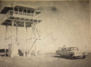
We traveled on to the lookout tower where amiable Cliff Runte greeted us with a hospitable grin. His home here is a square room atop a tower, glassed on all sides with the simple furnishings of stove, table, bed and chairs arranged around a circular fire-finder in the center. Here Mr. Runte commands a 360-degree view which is recorded every 15-minutes. A lookout for 16 years, he was stationed at this particular site during the 1948 fire when the tower burned to the ground.
He spoke of lightning striking during a November 1960 storm, which literally made things jump in the tower. An independent type, Runte enjoys his summit solitude yet has plans for extensive travel some day.
With the aid of a map drawn in the dirt, Ranger Parkinson surveyed the district lands and explained to me the need of further access roads in order to penetrate the mountains effectively. He spoke with enthusiasm of the changing concept of national forests, which has progressed from a viewpoint of forests as strictly a reserve, to today’s concept of public enjoyment and utilization of forest areas.
Recreation to Grow
Predicting that by 1970 the industry of recreation in Ventura County would be second only to oil, he spoke of the minimum funds available for campsite equipment and expressed hope that through cooperative efforts with the county, more forested areas would be available for public use.
He told me of the great Sespe Wildlife Area, closed except for the public Oak Flat Road from Fillmore. Entailing a separate management plan, this area is a reserve approved by the Secretary of the Interior for preservation of the condor. A governing board of three men (the president of the Audubon Society, the wildlife manager of the regional office in San Francisco, and one other person, usually a specialist in ornithology) must approve any activity in the area, such as road building, gas and oil leases, open corridors for fishing sites, or grazing permits. The National Audubon Society contributes to the salary for an officer in this area.
We talked a little of the PUMA county road plan which will utilize Seabee activity in the Rose Valley for a highway coming from Route 99 and joining with Route 399 as a direct inland route to the coast. Possible dam sites in the Sespe basin will further open up the now inaccessible areas.
I was interested in a map which showed private property within the forest and learned that zoning in these areas is within county jurisdiction, but most are in an A-1 designation at present. Private ownership in the Forest dates to the Teddy Roosevelt administration when the 1890 Homestead Act was discontinued.
May Trade Land
There is a plan whereby property owners may trade their holdings within the forest for lands on the boundaries, thus consolidating national property. Parkinson touched on the need of cooperative planning along the borders toward compatible uses with county land planning.
The district’s land use plan, which is revised every five years, includes the following primary components:
1) Fire Plan, 2) Recreation Resources Inventory, 3) Wildlife Management, 4) Grazing Plan, 5) Five-year New Construction in Recreation, 6) Trail Construction Program.
Of county concern are the flood control districts for fire prevention and watershed protection for the Casitas and Matilija Lakes areas. County funds contribute to salaries of officers in these districts.
I inquired as to whether trees had ever grown on the rugged slopes of the range and learned that indications of redwood and ponderosa pine have been found. In Ventura County part of a redwood tree was discovered while drilling at the 5,000 foot level.
Parkinson spoke of the plans for reseeding and said that 250 redwoods had been set out in twelve different areas as a trial planting.
Anticipating little success with these, however, he hoped that a good rainy season would allow the planting of 500 Arizona cypress and big-coned firs for further experiment.
He told me of conversion methods whereby an area can become less of a fire hazard through chemical, mechanical and burning controls. The chemical method is an expensive process but might be used in an area such as surrounds Ojai, where fire danger to the city is eminent.
Meets With Boys
In addition to management problems Ranger Parkinson last year addressed 57 organizations, 7 high schools and many Scout troops. He meets with boys interested in forestry as a career and had organized a learning program in cooperation with the schools whereby two or three students from each high school actually work with the forestry personnel for one week doing fire prevention work, range management, campground reconstruction and trail maintenance.
“This is a healthy interest among county children in conservation and forestry,” he stated, and cited an example of 250 students last year rehabilitating a campground near Santa Paula, using their own tools and raising the necessary funds. He spoke with deep conviction and enthusiasm of the concept of the National Forest as a dynamic county inventory and mentioned that in actuality he represents the largest landowner in the third supervisorial district.
His pride is contagious, and as we ricocheted our way down I felt I had been introduced to a new world whose horizons beckon with adventures beyond the confines of our Valley.