The following article first appeared in the December 31, 1969 edition of “The Ojai Valley News” on the front page. It is reprinted here with their permission.
Review of the Sixties — Part 4
Freeway fighters win scenic highway battle
by Gary Hachadourian
(This is another in a series of articles reviewing the Sixties in the Ojai Valley.)
Early in the Decade the state legislature passed the Scenic Highway Act and then asked the counties which roads they wanted designated as “scenic highways.” Ventura county supervisors fingered Highway 150 from Santa Barbara to Santa Paula — through the Ojai valley — and that’s when the Battle of the Scenic Highway originated.
In the beginning, there was no opposition. In fact, if you had asked the average resident how he felt about Highway 150 as a “scenic highway,” the reply would probably have been “just fine.” It wasn’t until the state decided to choose the route that the first shots were fired and the battle joined.
The word “freeway”
In the beginning “scenic highway” had meant to the public, in essence, “making the highway more scenic.” When the state came forward with varied routes, residents soon learned that the new Highway 150 would be built according to “freeway standards.” The word “freeway” had alarming connotations and the issue at once became emotional. Few people wanted another freeway through the valley.
Between Ojai and Upper Ojai, four routes were being considered, the state announced. Though public sentiment was anti-construction, citizens early came to favor a route through Lion Canyon to the south of the city, away from the valley floor.
The Division of Highways had previously ceased to consider that route; but in what was seen as a partial victory for opponents of the highway, the state announced that it would re-study Lion Canyon, a more “expensive” route.
In May of 1967, however, at what was to become a turning point in the history of the battle, the newly formed Committee to Preserve the Ojai determined that it would actively oppose any selection of routes. In August of that year, the East Ojai Valley Associates, which up until then had been urging strict standards in construction made the same decision.
Throughout the next year, the Division of Highways persistently urged the city and county to agree on a route of its own accord and plan to set aside a “corridor of beauty” along that route in order to ensure that the scenic highway would indeed be scenic.
Huge petition
The City Council, in September of 1968, resolved that the Lion Canyon route was most desirable, a decision that sparked the Committee to Preserve the Ojai to get thousands of names in opposition on a petition.
When the all-important public meeting between state engineers and the aroused public came in October of 1968, the Committee to Preserve the Ojai presented a map of the valley on which each landowner who opposed all construction had his property colored red. Color the valley red.
The issue was not decided, however, until late 1969. At the urging of the City Council and the Board of Supervisors, the state agreed to postpone route adoption “for an indefinite period” in order to consider, first, “new priorities in valley road construction.”
The force of public opinion had triumphed.
There was irony in this “victory.” Opponents had been fighting to keep the valley rural by opposing the road. But it was the effects of urbanization that had brought the new road work priorities into existence and cause the state to lay off the scenic highway.
Traffic volume in the valley had grown to the point where, because freeway construction was falling behind schedule, the interim widening of Highway 33 between Foster Park and Ojai took precedence over the construction of any new road. More people in more cars needed to get in and out of the valley.
And the traffic volume within the City of Ojai had doubled. In December of 1967, City Manager Jack Blalock said that the city’s number one problem was traffic congestion in the downtown area.
In order to ease congestion, the city felt, the state should approve and construct a loop of two one-way streets in the downtown area along its state Highway 150 route.
And the loop was intended to solve not only traffic problems.
For, throughout the decade, another type of outside pressure on the valley had worked to force change within it. And though, in this case, the force was indirect, it was nonetheless real.
Ojai’s business community, with some exceptions, was suffering. As the decade progressed, the situation became increasingly pronounced to the point where, in 1968, despite population growth, taxable sales were the same as they were in 1964, this despite the fact that prices had gone up.
Promoting this situation was, of course, the development of new, convenient and competitive shopping centers in nearby cities, most notably in Ventura.
Absentee owners
Promoting it, also, was the fact that many owners of floor space in Ojai’s historic and distinctive shopping area, the Arcade, were absentee owners. They showed no inclination to spend money needed to refurbish their properties, even to the extent of making them structurally sound. (In 1966, an engineer opined that the Arcade could collapse in a severe earthquake.)
And the forces pressing for action became compounded in the latter half of the decade when the then unincorporated area along Maricopa Road to the west of the city quite clearly was being considered as a target site by commercial developers.
Also, in the untouched Santa Ana Valley a few miles away, county planners in 1967 approved plans for a 512-acre residential and golf course development that would include a new shopping center.
The traffic loop of two one-way streets in the downtown area was crucial to a plan to turn the tide. Getting the state to approve and construct a loop became the city’s number one priority. Thus, the Battle of the Scenic Highway was an ironic “victory” for Ojai.
The outrage was only reactionary, a response to the continuing force of urbanization.
If Ojai truly was to determine its future, the valley would have to anticipate events; would have to search its soul in an effort to decide what it wanted; would have to take steps to ensure that no unmanageable situations could even arise.
It would have to plan carefully, and completely, and stand by that plan.
Spelunking and other Vignettes from Drew’s Boyhood Days
The following article first appeared in the FALL 2021 (VOLUME 39 NUMBER 4) issue of “Ojai MAGAZINE”. The magazine was published by the “Ojai Valley News”. With their permission, the article is re-printed here.
LOOK BACK IN OJAI
with Drew Mashburn
Contributed on behalf of the
Ojai Valley Museum
Spelunking and other Vignettes from Drew’s Boyhood Days
Spelunking: There once was a tunnel that ran under the street in downtown Ojai by a creek bed. When I was a young teenager in the mid-1960’s, the tunnel ended behind a pharmacy in the Arcade. What made the tunnel a bit scary was the fact that it doglegs. Why was it scary you ask? Because my buddies and I would gingerly walk through it so as not to stumble over the rocks in the dark until the mid-way point where it bends. Back in those days, the dentist whose practice was next to it didn’t dig us kids using her stairs to get down to the creek. So, we had to be sorta stealth-like. Once we got to the tunnel’s midway point (the dogleg as we called it), light began appearing from the other end. But many times, just before we began to see the light, older teenage boys would be hiding in the darkness. As we approached they’d start screaming and scare the pee-waddin’ outta us! We’d take off runnin’ for the opening behind the Arcade, then scamper up the steep, weed-covered creek bank. Back then, there wasn’t an “Arcade Plaza.” In fact, the back of the Arcade was pretty sucky-looking. We didn’t care though, because we had just survived a cheap thrills adventure.
Read the rest of the article directly from the Ojai Magazine.
Review of the Sixties — Part 3
The following article first appeared in the Sunday, December 28, 1969 edition of “THE OJAI VALLEY NEWS” on the front page. The article is reprinted here with their permission.
Review of the Sixties — Part 3
Urbanization — the story of the decade
In this, the third of a series of articles reviewing what happened in the Ojai Valley during the Sixties, reporter Gary Hachadourian takes a close look at the causes and effects of urbanization on the once-rural valley. “Urbanization” is the hallmark of the past decade, according to reporter Hachadourian, who spent months scanning the front pages of the Ojai Valley News of the years 1960–1970.
by Gary Hachadourian
The urbanization of the Ojai Valley was forced upon it — forced in three ways:
By pressure from outside the valley;
By pressure from within it, generated to ensure that growth would be ordered along predetermined lines, rather than haphazard.
And, once urbanization began, it was forced by the “system” and by the power of the valley’s “personality.”
These forces were not isolated one from another; there was no strictly sequential order in which they made themselves felt. They coexisted.
But the forces of urbanization here did make themselves felt, for the first time at least, in roughly a sequence. So, for the purpose of simplifying this article, they probably should be handled that way.
From outside
First, then, the forces exerted on the valley from outside it.
They ranged from the vague and unnerving thought that the golden Southland was growing and would soon need more space in which to grow, to the very specific and community-rallying force exerted by the state as it went ahead with plans to construct, first a freeway and then a scenic highway along the valley’s floor.
In 1960, a study reported that the population of Ventura County, set then at just under 200,000 would double within 20 years. The report named Ojai as a target area for residential development and said that the valley’s recreational areas would lure many vacationers.
(As it turned out, that report was modest. For the county’s population has almost doubled in ten years rather than twenty.)
In 1962, a professional firm doing a land-use study for the county forecast that the population of the Ojai Valley, in fact, would more than double in 20 years. This firm, which had also been commissioned by the City of Ojai to draft a general plan for development, said valley population would jump from its current level of about 15,000 up to 40,000 by 1985. Later forecasts would predict even greater jumps.
(As of this year, population of the valley from Casitas Springs to Upper Ojai has risen since 1960, to just under 22,000.)
A person who lived in Ojai during these early years of the decade might have doubted the actual figures in these reports if he had wanted to; but there was no way for him conscientiously to deny the forecast of growth.
County growth
The county was developing rapidly during these years. Most of the development was (and is now) taking place in the southwestern part of the county, in those areas closest to Los Angeles. But it was occurring also in Ventura and Oxnard. More significantly, it was primarily commercial and industrial development that was going on in this, the coastal area.
But, in the valley, it was seldom pressure exerted for the expansion of industry. County and state officials and private developers certainly realized already (though not to the extent they one day would realize) that the valley would not readily accept any development that clearly might damage the area’s looks or threaten its cleanliness.
Besides (and perhaps more importantly), it is the nature of successful developers that they know what uses can be sold to a community for a given piece of land.
So the pressure on Ojai was not for industrial expansion. Predictably, and true to the forecasts, it was for residential development.
And what was learned by valleyites as the proposals for various subdivisions came in was that many developers, while they obviously agreed that the Ojai should be developed residentially if at all, had their own ideas about the location, type and density of housing that was desirable.
In many instances, also, county government bodies had ideas, that differed from Ojai’s.
Proposals came into the county or the City of Ojai for cluster-housing developments such as apartment buildings, trailer parks and condominiums, in addition to the more standard (and, for valleyites, more acceptable) tract subdivisions.
And what was built was bought as people settled on the valley as a place to retire to, or as a place in which to escape the haphazard and oppressive development of metropolitan areas and find joy again in nature, or as a place, quite simply, which was close enough to the office in Ventura and had available housing.
Action in the county
Of the two types of proposals — those for developments either within the City of Ojai or on unincorporated territory — the more important ones, were those for county land.
(Ultimately, the developments that were proposed and carried out within the city had, and will have, greater impact on the long-range future of the valley. But that is another story. The proposed county developments were more significant at the beginning of the decade.)
The proposals for the development of unincorporated land forced the city to look about itself; forced a renewed realization that what happened in any part of the valley affected the whole of it.
Therefore, the City of Ojai joined residents of the outlying areas in their concern when, for instance: the 121-acre G-Z Ranch was sold for possible industrial development in 1962; when a 40-acre, 356-unit mobile home park was planned for the south slope of Krotona hill in 1964; when a $3 million subdivision of 38 homes was proposed for the Dennison Grade in 1966.
These developments were seen as undesirable by Ojaians. County supervisors, though, were not so partisan. Ultimately, the developments were not carried out because: in the case of the G-Z Ranch, plans were never presented (the area now, however, is being considered as a site for a mobile home park); in the case of the Krotona mobile home park, supervisors refused a permit; and in the case of the Dennison tract, supervisors placed what amounted to economically prohibitive conditions on the use permit.
Supervisors were not without political motivations in arriving at their decisions. One factor in their decision-making was the public interest in the issues shown by Ojaians.
Valley-ites had discovered a weapon they could use to fight unwanted developments.
It was a weapon that would be used many times during the decade — force met with force, the complexities of back-room politics met with the straightforward simplicity (and sometimes, the simplistics) of an indignant populace, the nebulous but undeniable pressure for change met with the rage of frustrated, and bitter protectionist citizenry.
The fact that public outrage was quite often a negative weapon — negative in the sense that it was nothing other than reactionary — seemed to go unnoticed by many people. Public demonstrations were (and are) justified as the people forcing an unresponsive and sometimes devious government to respond to the public’s desires to preserve Ojai. Partly, they were that. But partly, too, they were an expression of a conscience that knows it has waited too long before speaking out; and an expression of frustrated isolationism.
But if public outrage was sometimes negative, it was also, at times, positive — to the extent that no other course of action was available to the people.
And the best examples of relatively positive outrage were the Battle for the freeway and six years later, the Battle of the scenic highway.
Both battles, of course, were centered around the desirability of having a major highway running along the valley’s floor in the area of Ojai. But the battles differed insofar as the sensitivity of the opponent was concerned — his sensitivity to the feelings and the do-or-die dedication of the valley-ites. (The proponent, naturally, was the state.)
There’s been a change
During the Battle for the Freeway, the state’s champion, the Division of Highways, was as insensitive in his proposal as he was intractable in his stand—at first.
Six years later, however, the Division of Highways showed considerably more restraint, more willingness to compromise, as it pushed for the adoption of a mutually agreeable route for a scenic highway. In fact, it urged the City of Ojai to protect itself by planning a “corridor of beauty” for the route.
(Late in 1969, the Div. of Highways’ handling of Ojai would finally be directly opposite to what is was earlier. The division would request the city to hold a public hearing on the proposed traffic loop in the downtown area before—before—the state arrived at a recommended route. This so that the state could know the feelings of Ojaians before they spent the time and money on possibly objectionable route studies.)
Residents of the valley, however, showed no such inclination toward large compromise in the scenic highway issue. Their determination was as steadfast, their views as adamant, as they had been when the freeway was discussed.
The frustration and even anger of highway commissioners was apparently complete when valleyites reared up at them this second time, over the scenic highway; for, from their point of view, they were pressing only for a type of highway which the valley had determined years before was acceptable.
In the Battle for the Freeway, then, it was nothing less than the State of California that was the force pressing on the valley from the outside for change.
The Division of Highways, with its tendency to see beauty as a straight line between two points, saw the need for a freeway to Los Angeles by way of an inland route. The valley’s floor was not only a conveniently flat roadbed; it was also the route indicated in the state’s master plan for highway development.
This plan, the state’s engineers explained, was drawn with an eye toward the future needs of the target area (i.e., its projected population growth) as well as with an eye toward convenient traffic flow throughout the state.
It would be a freeway to serve anticipated needs. But since a freeway promotes development in addition to serving it, the valley was, inevitably, to be “opened up.”
There was never any question about whether it would be built. The state had its prerogatives, after all. The battle was over the route it would follow.
The Division of Highways, to the amazement of Ojaians, believed that it should pass through the City of Ojai. In 1960, residents viewed posted drawings that showed no less than 15 alternate routes through the city, some of them along Ojai Ave through the downtown area.
It is an understatement to say that residents’ feelings ran high.
The Ojai City Council, under the leadership of Mayor Robert Lagomarsino (now State Senator) was urged to protest. Certainly, the council would have done so of its own accord.
Of the many alternatives proposed by the state, the majority of Ojai citizens, recognizing that some route would be adopted, favored a route to the south of the city, along Creek Rd. Next in preference was the Ventura River bed route through Meiners Oaks.
It was this second alternate that the council urged the state, saying that a freeway was not needed through Ojai.
The public was quick to sign a petition that endorsed the council’s resolution.
On September 1, 1960, residents turned out in force for a meeting of state engineers and the public at Matilija Junior High. Engineers were insistent that the projected traffic volume of the city made a city route necessary. The audience disagreed.
No decision was made, of course, and residents left the meeting with the disturbing feeling that the state might not respond to their desires.
River route
Subsequently, the council formed a Freeway Study Group of selected citizens with the aim of providing the state with a more thoroughly considered opinion from Ojai residents. This group, too, recommended the river route after two months of study.
In May of 1961, the state announced that it would delay route adoption in order to give it more thought.
And a year later, in May of 1962, the state opted for the river route. (In addition to being the route desired by valley residents, it was also the cheapest.)
Residents were elated. In a figurative sense, at least, handshakes were passed all around, congratulatory.
Public sentiment clearly was a weapon that could be used to determine the future.
Somewhat determine it. The city was left intact, but the freeway, nevertheless, was now a reality. And the freeway, as a force, would promote an urbanized valley at least as much as it served it.
Five local parks men to be honored for valor
This article was run in the “Ojai Valley News” on page A3 of the Wednesday, April 19, 1978 edition. The author is unknown.
Five local parks men to be honored for valor
Five Ojai Valley men employed by the Ventura County Parks Department will be honored at the Peace Officers Association of Ventura County’s 5th annual Medal of Valor Awards Dinner April 21. Thomas [Drew] Mashburn, Larry Bintz, Mike Payton, Rip Reed and Bob Bordasch will each receive the Citizen Award for Distinguished Service for their rescue of U.S. Forest Service officer Jim Schellenger from Matilija Canyon floodwaters in February.
Schellenger was hiking along Matilija Canyon Road just past the campground taking photographs of flood damage. He safely crossed a section of road that had been washed out, traversing a narrow ledge about 3 feet wide by 10 feet long. When he returned, the ledge was gone, leaving a breech of about eight feet. To one side was a sheer rock wall; to the other, flooded Matilija Creek.
SCHELLENGER TRIED to scale the wall to cross. A rock he used as a handgrip gave way, and he fell into the river, where he was immediately swept downstream about 40 yards under water. When he finally struggled to the surface, he saw a drain pipe jutting from the river bank, grabbed it and climbed atop. Still in the river channel, however, he could not climb up the bank.
When he called for help, the five park men came to his rescue by forming a human chain to pull him to safety.
The Peace Officers’ Association, which is comprised of officers from all federal, state and local law enforcement agencies of the county, sponsor the Medal of Valor Awards Dinner to recognize citizens and police officers who have risked their lives to save a life or apprehend a dangerous criminal. The dinner will be held at the Oxnard Community Center, and tickets can be purchased through police or sheriff’s departments.
Are we ever to do anything about it?
The following article first appeared in the December 31, 1969 edition of “The Ojai Valley News” on Page D-6. The author is unknown.
Guest Editorial
Are we ever going to do
anything about it?
(This is the second half of an editorial which appeared in the October 15, 1969 edition of the Novato Advance, a weekly newspaper serving North Marin county, 25 miles north of San Francisco. The editorial was sparked by a 1,800 pad trailer park seeking approval in the area.)
* * *
City councils and planning commissions, by the character of the people who traditionally are elected or appointed to such bodies, are powerless to lead citizenry to any alternate way of life. As part of the system, they represent the values of the system as merciless and destructive as they are. With an occasional exception, they act as undertakers of the communities they govern, burying without ceremony those amenities which made the community in its early life history bearable and worth preserving.
Planning commissioners are incapable of planning — planning the community in terms of the wants and needs of its inhabitants rather than along the lines demanded by construction restrictions, by conventional standards, by expected norms, and accepted planning principles, hopelessly out of date by the time they are enunciated.
The only substantial function planning commissions and council play is to upgrade standards, and set up hearing processes which a developer if he is patient enough will in time outlast and breach. The automobile has led to basic changes in our civilization, most of them disagreeable. It has brought about the deterioration of our inner cities; led to the scatterization of suburbia and to the fragmentation of the suburban community so a sense of community is barely realizable.
The planners go merrily on catering to the automobile, raising the standards of streets, the parking lots which gobble up so much valuable downtown ground, allowing uses catering to an automobile clientele rather than pedestrians. The Novato Square, a key block in downtown Novato for creating a viable central district, has been sacrificed for the pleasure of the public traveling through Novato and patronizing drive-in hamburger joints and restaurants, instead of being preserved for businesses enhancing the community instincts of the residents here.
Planning commissions raise standards for hamburger joints, so that they not longer may be joints, but the basic purpose remains the same, converting downtown property for uses that are basically non-community. Higher grading standards are set, but in any critical case, which may involve community “progress” the bars are let down.
Planning commissions also set higher standards for mobile home parks, so that they are not longer trailer parks but mobile home parks. City ordinances have been rewritten to assertedly have greater control. The ultimate questions are never discussed in a study of mobile home parks, only the question of what standards should apply. The standards have been raised, so what? Five years from now they will be out of date. What about the standards of the community? Have these been set to determine if proposed development is inimical or friendly to our way of life here?
Goals are always expressed by planners, particularly by professional staff members, in the most acceptable of banal terms, representing standards in American culture which often have been in fact discarded or bear little relation to reality.
Residents here and elsewhere are often accused of being apathetic and unconcerned with civic issues. It is ironic to us when homeowners turn out in great numbers either in person or through representatives they have elected to serve them, their responses are so casually ignored.
More concern is spent on the wishes of the developers, on the inherent aspects of the plan, on the happiness of the future residents of the mobile home park, than on the present wishes and future goals of those actually involved in the day-to-day life of the community.
If certain technical conditions are satisfied, anything goes. Planners only see their roles as deciding how many mobile home pads should be permitted per acre rather than deciding whether a mobile home park is desirable in the first place.
Apparently it is more important for a plan to satisfy certain objective planning principles in order to be accepted than be acceptable to those whose community is being invaded by an alien and unwelcome forrce.
As we watch our council, planning commission and other local agencies at work and see them so often ignoring the lessons of the past, we increasingly tend to believe that we are losing the capacity to govern ourselves and solve the problems of the day, not only here but throughout the land. Who are we governing for anyway? Novato is being shaped by those who happen to want to risk capital here. Is this the only determinant that should be considered?
Are we ever going to do anything about it?
The Sixties in Ojai — Part 1
The following article first appeared in the Sunday, December 21, 1969 edition of “The OJAI VALLEY NEWS” on the front page. The article is reprinted here with their permission.
The Sixties in Ojai — Part 1
How has Ojai changed? Valley’s been urbanized
by Gary Hachadourian
Ten short days from now the decade of the Sixties will have ended.
How have the Sixties affected Ojai Valley?
What changes have taken place here in ten years?
The end of a decade is a convenient time to ask long-range questions because people think in units of ten; January 1, 1970, will seem like a new beginning.
It’s a time that’s convenient for pausing and reflecting.
But it’s also a very appropriate time to ask questions of the long-range variety since it’s always being said that things don’t happen overnight, and a decade certainly isn’t overnight.
See trends
Ten years is a long enough time to take a look at and get a good idea of trends.
In the case of a community, a sufficient number of things should have happened in ten years so that some statement can be made concerning where that town has been, what its concerns were, what its problems were, and, most importantly, where it’s going.
What a city does in one decade determines to a great extent what will happen in the next decade.
Well, has anything happened in Ojai during the Sixties?
Views differ
Your reporter has met a number of people who don’t live in the valley but who visit here regularly and say, “The thing I love about this place is that it hasn’t changed.”
He has met people who have been absent from the valley for a number of years and then have returned to find it, in their opinion, “Just like it was the last time I was here.”
On the other hand, the reporter is friendly with a lot of people who have lived in the valley throughout the Sixties; and he must smile fondly when he says he knows a few people have lived in the Chumash Indian’s Valley of the Nesting Moon for a lot longer than ten years.
These people don’t see the valley as being the same. In fact, they see great changes.
The things they say most frequently are, “I’m afraid for this city, Gary,” or, “I just don’t like what I see going on.”
What’s happened
So what has happened? Physically, tangibly, what changes have taken place since January 1, 1960?
Who’s right — the visitors or the old-timers?
They’re both right.
It’s true that when you compare the amount of actual development that has taken place in Ojai with the amounts that have taken place in other cities — the cities many of the visitors came from — not too much has happened in the valley.
A significant amount of development was carried out in the western end of Ojai’s downtown. Also, a shopping center was constructed at the “Y”, and a hospital and various other office buildings and professional centers.
Otherwise, little
As for the rest, it was residential development; and when you compare the residential development level in the valley with what occurred in other areas of Ventura County — Thousand Oaks and Camarillo, for instance — it really wasn’t too much.
During the Sixties, the population of the valley from Casitas Springs to Upper Ojai rose from about 15,000 to a little under 22,000. This is a healthy jump, but not a staggering one when you consider that professional planners have said the population would more than double to better than 45,000 by 1985.
During this same period, the population of Ojai has risen from 4,700 to 5,800, close to 25 percent. But still, that’s only 1,100 people, and a total population of 5,800 is a far cry from the 15,000 that anticipated by planners by 1985 (in an area between Maricopa Road and Gorham Road — slightly larger than the present city limits).
So it’s true that when you compare Ojai with other areas, growth here has been a little bit here and a little bit there — hard for a visitor to see.
Something crucial
But it’s also true that something crucial has happened in the valley during the past ten years. In the end, the old-timers are more right than the visitors in their assessment of the decade.
They can smell something in the air beside a whiff of smog, occasionally. Since they’ve been here for many years, they can sense any change in the trend of things.
What happened was much more subtle than physical development. But it was no less real.
Became urbanized
What happened was that the valley became urbanized.
Much will be made of this term — urbanization — as your reporter sets down what he thinks were the thematic occurrences in Ojai since 1960. So he’d better describe what he means by the term.
Urbanization is the process that changed Ojai from a rural town to a suburban center. It was as much a change in the thinking of the valley residents as it was a change in the physical development of the area.
When people start complaining about dogs running loose, horses in the streets, that ‘s urbanization as much as building apartment houses is.
Natural process
Urbanization really was an entirely natural process in the valley. The 7,000 or so people who have moved in since 1960 were, after all, essentially city dwellers. Many of them moved here simply because they needed housing that was within commuting distance to the office in Oxnard or Ventura.
As those cities began to fill up, other areas began to develop to accommodate the overflow. The valley was one of those areas.
Of course, many of the people who moved in came by choice as well as necessity, wanting to live in a pretty place that was quieter, more restful, and more personal than an urban center. Even so, they brought with them a different type of thinking.
The point is that as the population explosion began to make its effect on the valley, the thinking of the majority of the residents began to change. The majority’s tastes changed. Its thoughts on what an appropriate future was began to change.
Small wonder that the old-timers feared what they sensed was happening. They, the people who would fight tooth and nail to keep the valley a rural paradise, were becoming more in the minority.
Lack of control
But it wasn’t only that the valley was developing that worried these old-timers. What they really feared — and what the reporter fears, he should add — was that the direction of growth wasn’t being sufficiently controlled.
Ojai, as many people who are only occasional visitors know, is a beautiful place. More significantly, it has the type of beauty that can bring in money by being left as it is.
Those mountains that rise up less than a mile from the center of the city are the impressive boundaries of a national forest. There’s a lake nearby and many parks and many miles of riding and hiking trails, not to mention golf courses.
Ojai obviously should be a town that is a recreational oasis for the real city dwellers to the south of here, in the Los Angeles area. It should be an oasis for its own residents, most of whom have chosen to live here in order to escape the oppressive mode of living in other Southern California cities.
Stress planning
This article, which will be published as a series over the next few weeks, will seek to identify what the city’s problems have been during the Sixties as far as planning its future and implementing its plan goes.
In that vein, the reporter will discuss what the combination of forces was that brought about urbanization. In his mind, there were three basic forces at work:
* Forces exerted on the valley from the outside — essentially the population explosion.
* Forces that worked from within the valley — i.e., the need to urbanize and develop in a chosen direction in order to prevent the valley’s being developed haphazardly, at the whim of developers. Emphasis in this section will be on what type of planning the city actually did and what steps it took to make itself an oasis for tourists and its own residents.
The ‘system’
* Forces that prevented the city from controlling the future as much as it would have liked to. Ojai had a personality that was sometimes self-defeating. Also, it lived — and continues to live — under an economic “system” that made it difficult and even impossible to act in accordance with its desires all the time.
The reporter will also discuss what he thinks was a sterile and self-defeating philosophy of government during these years. As will soon become clear, the reporter is eager to shout congratulations for the steps the city’s government has taken to identify and preserve the character of Ojai, to channel its growth.
But he will point out also that a philosophy of government that stresses the right of a property owner to develop his property as he sees fit, rather than a balance between those rights and community responsibilities, is a philosophy that’s incapacitating and essentially murderous to a community.
Lack of imagination
In some instances, he feels the city planners and elected officials have shown an abysmal lack of imagination and guts. While government has taken some life-giving steps, it has also served as the city’s undertaker.
Obviously, the reporter will not try to hide his feelings. He will try for objectivity, but not detachment.
Why? Because Ojai is important to him. It’s important because it’s his chosen home, but also because it is a unique town and has the potential to become something different, something more habitable for human beings than most other cities.
He should explain that he has lived here for less than two years, and so hasn’t experienced all that he will talk about. His factual information was gained by going through the 1,000 or so issues of the Ojai Valley News that have been published twice weekly since 1960. Also, there have been talks with many people.
The reporter’s particular interpretation of the facts stems from the belief that even though he didn’t live through everything he’ll write about, the type of thinking that people in the valley do hasn’t changed.
To a great extent, the reporter has undertaken this project to gain knowledge about what happened before he arrived in Ojai. He wanted to do it in order to gain a fuller understanding of what Ojai is, where it’s been, and, most importantly, where it’s going.
Examining a decade allows you to do these things — and that’s what we’ll undertake beginning in the next issue.
Drew learns to drive
The following article first appeared in the Fall 2020 (VOLUME 38 NUMBER 3) issue of “Ojai MAGAZINE”. The magazine is published by the “Ojai Valley News”. The article is reprinted here with their permission. Photos provided by the “Ojai Valley Museum”.
LOOK BACK IN OJAI
with Drew Mashburn
Contributed on behalf of the
Ojai Valley Museum
Drew learns to drive
Sex did not happen for me at 15 years old, but the next best thing did.
Let me explain. Mom was pregnant with my second little sister and fourth sibling, Mindy. Mom was a shorty and her belly got so big that her short legs would no longer reach the pedals in our 1959 Ford station wagon. So, she asked me if I’d like to become the family driver when Dad was at work. It took me all of three whole seconds to exclaim “Yes!” Mom explained I was so close in age to being eligible for a Learner’s Permit (15 1/2 years), if the police spotted us, they’d assume I had a permit. Fine with this soon-to-be Roadmaster! Mira Monte Market, here I come!!!
Read the rest of the article in the Ojai Magazine.
MEANING OF ‘OJAI’ IN DOUBT BUT INDIANS HAD NAME FOR IT
The following article was first run in the FRIDAY, NOVEMBER 28, 1947 edition of THE “OJAI” on PAGE TEN. THE “OJAI” is now the “OJAI VALLEY NEWS”. The article is reprinted here with their permission. The author is unknown. Photos have been added by the “Ojai Valley Museum”.
Articles from the past often contain historical inaccuracies. History changes as new information is brought to light. Please read the notes from a local historian below the article for updated information. Or better still, purchase a copy of “The Ojai Valley: An Illustrated History” 3rd edition.
MEANING OF ‘OJAI’ IN DOUBT
BUT INDIANS HAD NAME FOR IT
__________
“A-hawai,”[1] was how the early Indians of the Ojai Valley pronounced what we now call “Ojai,” and they spoke a Chumash dialect; but what it means, has long remained cause for difference. The various Indian dialects used the word with different interpretations, but for many years has been accepted to mean “nest,” (although a number of persons have claimed that “moon” is the proper interpretation.)
However, because of the area’s geographical setting, persons viewing the twin valleys from an elevation are convinced that it resembles a giant bird nest, and for this reason feel that “A-hawai” means “nest.”[2]
[3]From “A-hawai” the name was developed to “Ojay,” and then to “Ojai” when the Spanish and Americans occupied the territory. In the middle of the 19th century, California was about the most interesting place in the world, or at least the entire world wanted to know more and more about this place called California . . . GOLD, you know, interested just about everybody . . . except, probably, a man known as Charles Nordhoff, who was more occupied with the coast scenery and writing about it and the people.
Nordhoff was a roving correspondent detailed by the New York Herald to do a few articles about this land by the Pacific shores. While roving around in the year 1872, he came across the Ojai Valley, and what he saw inspired him to write words so forcefully that two men gave a small location his name. [4]
In 1883, an R. G. Surdam purchased 1500 acres of land in the Ojai Valley near the San Antonio creek. Of this land he laid out 160 acres to be established as a townsite, offering 20 acres to anyone who would build a hotel on the property. A Mr. A. W. Blumberg accomplished this feat, and one day while the two families were discussing the townsite over a dinner table, the hotel builder suggested naming it Nordhoff, in honor of the man who wrote so enthusiastically about it. And so was it called in 1884. [5]
However, prior to this, in the Ventura “Signal” issue dated July 26, 1873, the first townsite in the Ojai Valley was advertised as “Ojai,” but this did not develop.[6]
And though legend has it that an unwritten law existed between the Indian tribes, in which the Valley would be utilized to discuss peace terms, and that wars would be religiously forbidden, the land was thickly populated with wild animals.
The early farmers were often troubled by the animals, and so were those who thought themselves safe behind locked doors. Thomas R. Bard, who was sent here to look after the interests of Thomas Scott, assistant Secretary of War under Abraham Lincoln, is reputed to have killed a bear in his bedroom in 1870. One year later, so say the history books, three boys lassoed a bear and brought it home to their astonished parents.
The town of Nordhoff was growing quite rapidly, and on October 27, 1891, the first issue of The Ojai was published at the Ojai library.
Just when the name of Nordhoff was changed to Ojai is somewhat confusing. One bit of reference claims “Ojai” was officially adopted in 1916, however, some records show that in 1917 a Henry Morse, then manager of the Foothills hotel, first petitioned to have the name changed. According to the newspaper masthead of The Ojai, the change from Nordhoff to Ojai appears in the May 4, 1917 issue for the first time. Evidently, however, the change must have been of little importance because there wasn’t a mention of the fact in that particular issue.
Why the name was changed, is still another story. Many people claim that Charles Nordhoff, born in Germany, was a German sympathizer during World War I. [7]
Nevertheless, on July 26, 1921, the townsite became officially known as the City of Ojai on a vote to “incorporate” by the people. On this occasion, a gavel, composed of East Indian Teak (off a wrecked English ship on Santa Rosa Island) and Iron Wood (found on Santa Cruz Island), was sent with a letter to the city council by a C. W. Rasey, of Santa Barbara, who wrote: “May the sturdy strength and tenacity of the materials of which this gavel is made, prove typical of the enduring future of your picturesque and beautiful little city.”
- ‘Awha’y’ (aw-ha-ee) was the name of a Chumash village in the Upper Ojai.
- Research and linguistic analysis has shown that ‘Awha’y means moon, probably in the cyclical sense.
- With the Spanish, the Chumash name ‘Awah’y became “Ojay.” Later, with the American settlers, the Spanish name was written “Ojai.”
- Charles Nordhoff visit the Ojai Valley in 1872, nor did his 1873 book, California for Health, Pleasure, and Residence, mention it. Nordhoff visited Ojai on a later trip to California, in 1881, and wrote about the Ojai Valley in the book’s second edition, published in 1882.
- Surdam laid out what is now the town of Ojai in 1874. Credit for naming the town “Nordhoff” is given to Blumberg’s wife, Catherine.
- The first proposed town was to be located east of what is now Gridley Road, on the ranch of Lorenzo Dow Roberts. Surdam beat him to it by platting the town of Nordhoff in a wooded area of the valley called “White Oak Flats.”
- There is no evidence that Charles Nordhoff was a German sympathizer. There was some antipathy toward German names during the time of World War I, but more likely Mr. Libbey suggested it because the name was more suitable after the Spanish makeover of the town in 1916-17.
THE PLANE TRUTH ABOUT OJAI’S AVIATION HISTORY
The following article first appeared in the Fall 2015 issue of “The Ojai Valley Visitors Guide” which was published by the “Ojai Valley News.” It is reprinted here with their permission.
THE PLANE TRUTH ABOUT OJAI’S AVIATION HISTORY
Story by
Perry Van Houten
Along the airfield’s perimeter was a low barbed-wire fence, and a grove of English walnut trees grew on the south and west sides. A few locals remember a restaurant across Highway 33 from the airstrip, The Airport Cafe, in the present location of Ojai Termite & Pest Control. A bar directly across Baldwin Road from the airstrip was known as The Refuge.
“AIRPLANE RIDES $8.00”
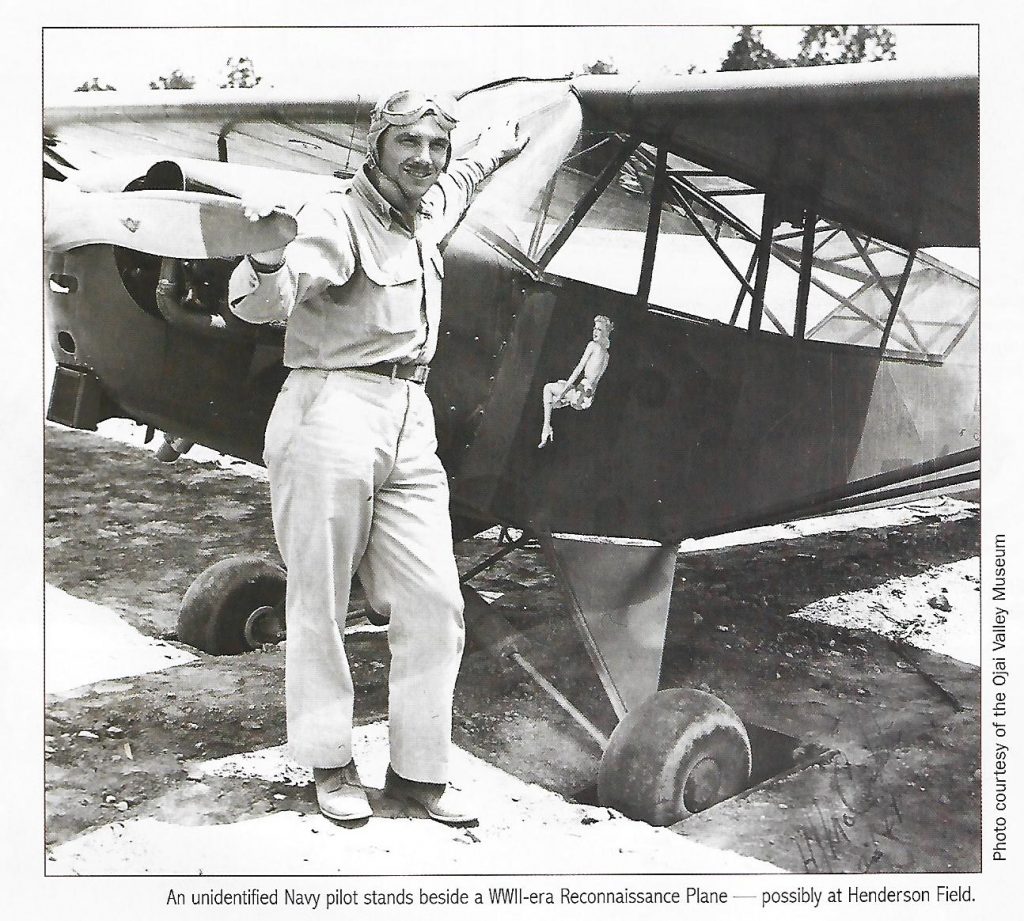
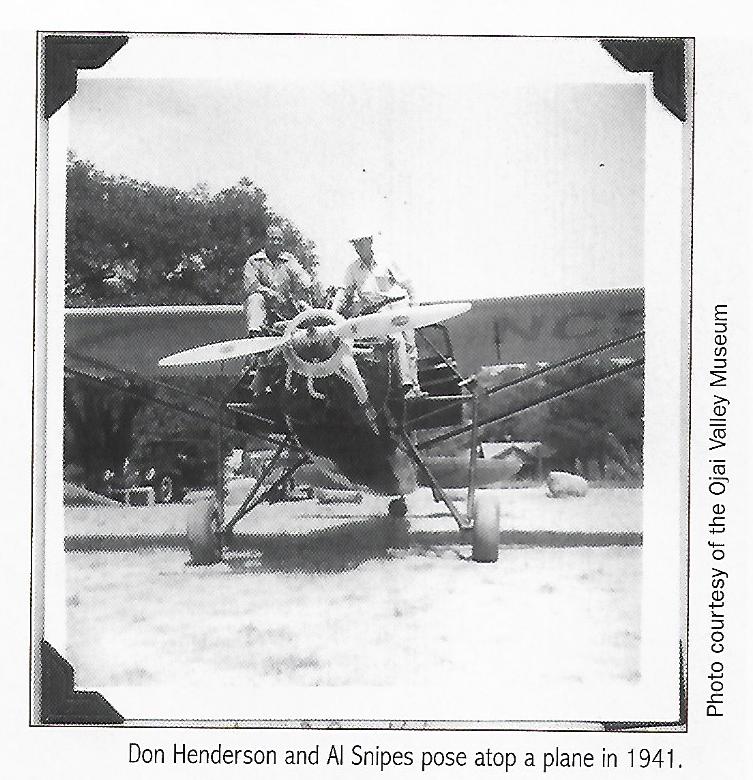
The sign was posted on the window of the two-seat Aeronca Champion parked at Henderson Field in Mira Monte. Twelve-year-old Drew Mashburn lived nearby on South Rice Road and might have been on his skateboard in 1964 when he noticed it. He had never flown in an airplane, and he knew this was his chance.
A few days later, Drew and his best buddy, Mark Madsen, 11, spotted the plane’s pilot standing there. They scraped together eight bucks between them, hoping the pilot would let them both cram into the passenger compartment of the plane. But the pilot insisted the price was $8 apiece.
The boys returned the next day, and the day after that, and begged. “I can remember the pilot actually threw his arms up above his head and he says, ‘Alright, I’ll go ahead and I’ll take the $8, and I mean not a penny less,’ ” Mashburn says. Wild blue yonder, here we come, he thought. His whole family gathered at Henderson Field for the occasion.
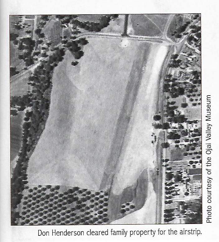
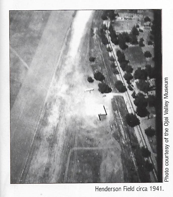
Henderson Field
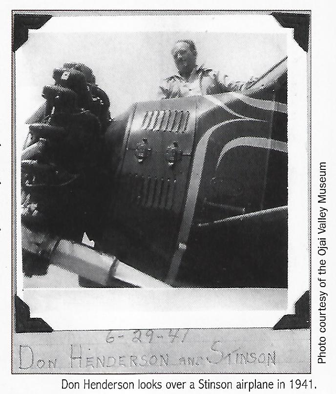
Don Henderson built Henderson Field in the 1940’s, on family property near the intersection of Highway 33 and Baldwin Road. He ran a small flying school there, commissioned by the Army Air Corps during World War II. For nearly 30 years, the 2,100-foot runway accommodated up to 20 aircraft per week.
Back in the ’50s and ’60s, a popular pastime was flying from local airport to local airport; for instance, from Santa Paula Airport to the Ventura Airpark at Pierpont Beach to Henderson Field in Mira Monte. Well-to-do folks from Los Angeles would fly into Henderson on weekends, including Hollywood stars like Robert Young, Claudette Colbert and Norma Shearer.
“It was the only real, genuine airport I knew of in the Ojai Valley,” says Santa Paula pilot Bruce Dickenson, who had just learned to fly and landed his Piper PA-12 at Henderson Field a few times in the late 1960s. “It was a non-event,” Dickenson recalls, although he remembers there was a big set of power lines pilots had to avoid.

In July 1945, Don Hendeson died in the crash of his small plane near the airfield. He was 37. His son, Don Henderson Jr., was 3-and-a-half when it happened. He says his father had taken off in the fog early one morning for Bakersfield when, for some reason, he decided to return to the airstrip. “He overshot the runway and ended up in the walnut grove, on fire,” says Henderson, now 74. “I often think about how my life would have been different if he hadn’t died that day.”
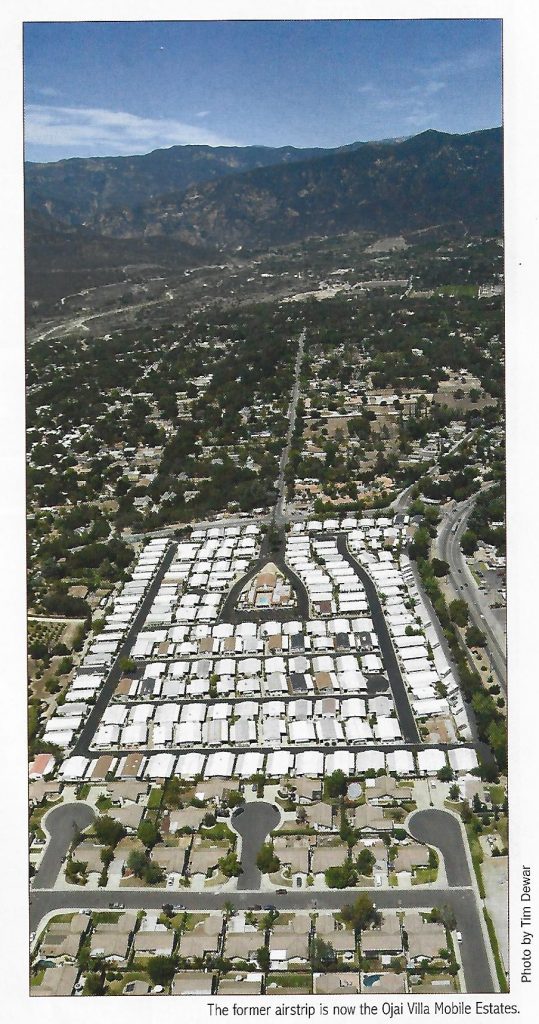
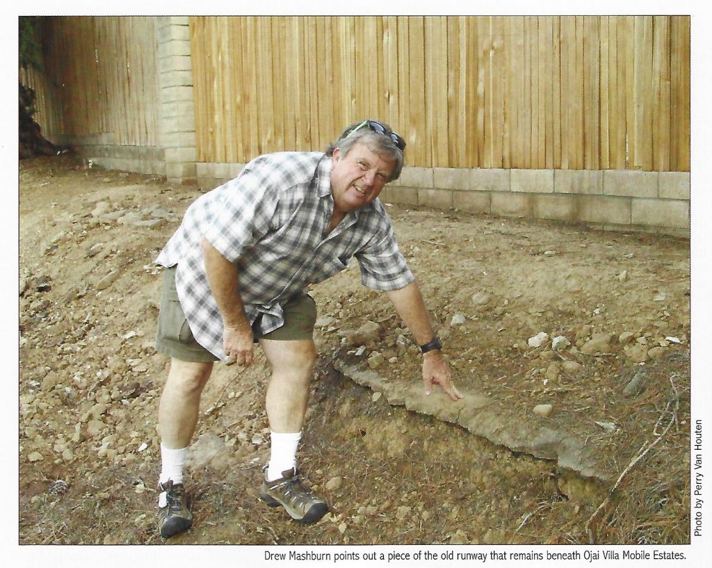
Henderson Field, which had gone public just six months before the crash, stayed in operation and even opened hangars and a waiting area — with restrooms — in 1949. Pilots landing at night remember being guided down by their wives, who would park at the end of the runway and shine the car lights. The airstrip closed around 1970 and was replaced by the Ojai Villa Mobile Estate, which is still in existence today.
Hardly anything remains of the old airfield, except a portion of the runway sticking through the dirt on the north side along Baldwin Road, and some cream-colored rocks. “Almost directly across the highway from AJ’s Express Chinese Food you will see several boulders. The boulders used to line the entrance to Henerson Field and the hangars,” say Drew Mashburn.
Other Ojai Airstrips
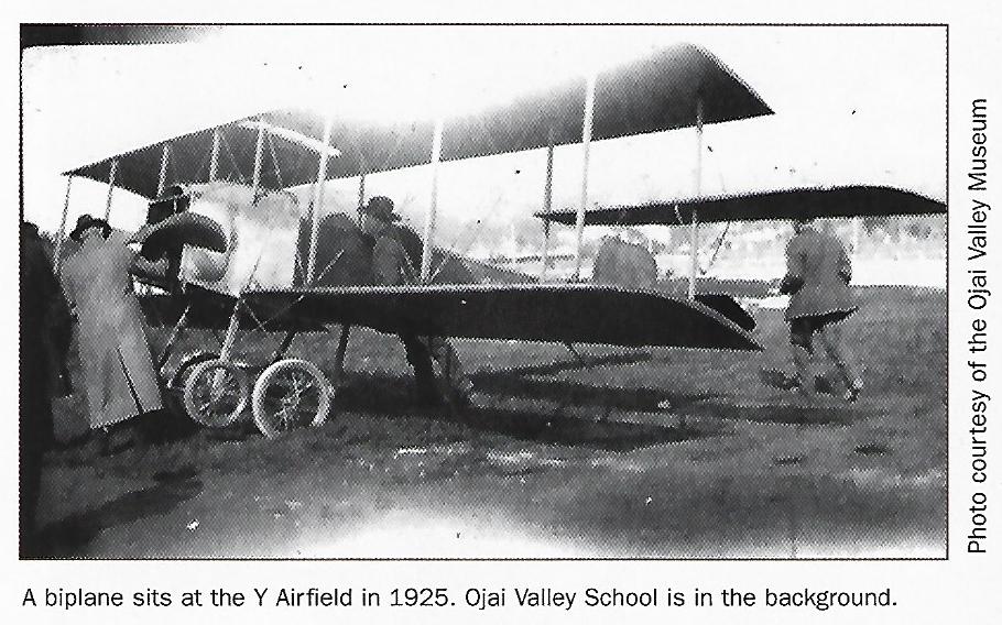
The Ojai Valley’s fondness for flying machines dates back to the earliest days of aviation. A 1929 aerial photograph shows a 1,500-foot airstrip near the “Y” intersection, where Vons is today. “It was removed around the time the Krotona Institute was built because the planes were taking off and landing right over people’s heads,” says Ojai historian David Mason. The Theosophical Society had purchased land south of the runway in 1924 in their move from Hollywood to Ojai.
Mason says a private airstrip on Rancho Cola near Lake Casitas may have been used in the filming of the 1950s TV series, “Sky King.” It was also used as a base for parachute jumpers. A landing strip in Rose Valley at Bodee’s Rancho Grande is shown on the 1991 USGS Lion Canyon quadrangle topographic map.
The Ojai area is also home to a number of heliports, including one that’s still in use at Help of Ojai’s West Campus on Baldwin Road — often referred to as “the old Honor Farm” by locals — plus several scattered throughout the backcountry that are utilized by fire, law enforcement and search and rescue crews. The late actor Larry Hagman had his private Majlar Heliport built on his estate atop Sulphur Mountain.
Crashes and Mishaps
When Ojai’s greatest benefactor, Edward Drummond Libbey, opened a new golf course and clubhouse in 1924, everyone wanted to check it out, including a Navy lieutenant who flew a military plane from San Diego to Ojai to see it for himself. “He circled the clubhouse a few times and then decided he would land on the fairway. But he nosedived into a sand trap and broke the propeller,” Mason says.
The damage to the aircraft took a couple of days to repair, and soon the pilot was airborne and on his way back to base, when again he had trouble. “He managed to take off from the green, and in doing so he hit the high wire running along Ojai Avenue, and it pulled the plane back down and he crashed again on the street, and broke the landing gear.”
Perhaps the most famous aviation mishap in the Ojai Valley was a product of Hollywood. Frank Capra’s 1937 movie, “Lost Horizon,” is based on the novel by James Hilton, who visited the valley in 1934 and exclaimed, “This is Shangri-La!” The plot follows a British diplomat and some civilians who crash land in the Himalayas. Some of the movie was filmed in the valley — although the Ojai footage reportedly ended up on the cutting room floor. However, the valley is still often referred to as Shangri-La.
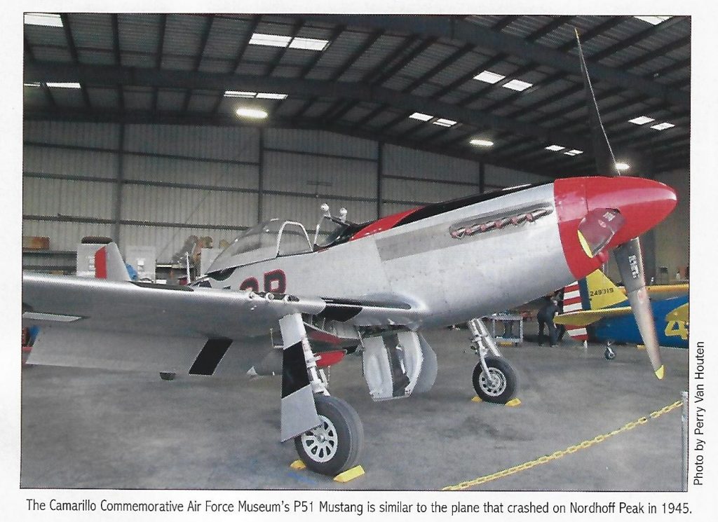
In 1945, a USAAF pilot crashed his P-51D Mustang fighter plane into Nordhoff Peak, just below the fire lookout tower, while attempting an emergency landing in bad weather. Since the crash, debris from the wreck has been found scattered all over the mountain. In 1980, a U.S. Forest Service controlled burn in the area accidentally ignited unexploded ordnance from one of the aircraft’s high caliber machine guns, leaving the work crew wanting for flak jackets.
An aviation mishap in the Ojai backcountry in December 1949 had a much happier ending. Twenty-six-year-old Glendale pilot Robert Bryant disappeared on a flight from Glendale to San Francisco. He was found a week later, several miles from the wreckage of his small private plane on Topa Topa Peak, in upper Sespe Canyon. A ground party struggled through waist-deep snow to get to Bryant, who survived but suffered from serious injuries and exposure.
First Flight
Back at Henderson Field, Drew Mashburn’s family looked on as he boarded the plane for his first flight. “We started to get in the airplane and the pilot turned around, looked at us and said, ‘Hey, how much do you guys weigh?” Mashburn knew what the pilot was getting at — there had to be a weight limit. “There goes our ride, I thought,” he recalls.
In despair, the boys gave the man their weights. It was too much, but the pilot gave in. “He said, well, that’s a little over, but we’ll make it work.” They climbed in and off they went down the runway. “It’s good we didn’t spring the door in mid-air and fall out,” Mashburn chuckles.
At first, Mashburn thought the little airplane wasn’t going fast enough to get airborne. “It didn’t seem like we were moving very quick. I thought we were going to move a lot quicker. The wheels of this thing were going down into the chuckholes, and that’s probably the reason we couldn’t pick up any speed,” he says.
Bouncing down the narrow strip of oiled dirt, the aircraft passed the Mira Monte Market (now Rite-Aid). In those days, Mirror Lake was down at the far end of the runway, where Woodland Avenue is now. “And that thing kept getting closer and I kept thinking, man, we’re just gonna land in the lake. And at the very last second, up we went, and it was just stupendous. It was like no feeling I’d ever had in my life.”

Creek takes ranger’s home
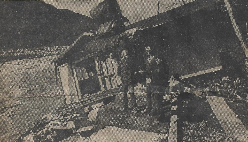
The following article first appeared on the front page of the Sunday, February 12, 1978 edition of the “Ventura County Star Free Press.”
Creek takes ranger’s home
‘We just got out of there in time’
By Gregg Zoroya
“I know I’m not afraid of the river now. I was before. Before, it looked like it was something out of the Grand Canyon. It looked like the Colorado River,” said Drew Mashburn, 26, county ranger for the Matilija campground area.
“Before” was the early moments of Friday morning when Mashburn and his 24-year-old wife Gene-Marie were driven from their home alongside the swollen banks of the creek.
As they turned from the home, wet and cold, with belongings that consisted of little more than the clothes they were wearing and escaped to a neighbor’s house, the raging torrent of Matilija Creek broke out and engulfed most of their house at 2088 Matilija Canyon Road.
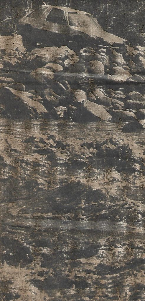
In the process of destroying the house, the waters swept away the Mashburn car, pickup and cab-over camper.
A weakened roadside on which their remaining vehicle was parked — a county car containing camera equipment and other family valuables — collapsed and dropped the car into the creek later that morning.
“We lost the front porch, we lost the front screened porch, we lost the kitchen, the dining room. We also lost the living room and the beautiful stone fireplace,” said Mashburn.
The house, remains of which sit precariously on the edge of the creek, is county property and was valued at $40,000 said Paul Lamp, county parks superintendent.
Besides the vehicles, the Mashburns lost much of their furniture — including everything from dining and bedroom sets to refrigerator, stove, television and stereo, and an antique victrola.
Mashburn declined to put a dollar estimate on the property that is gone, until his insurance company can estimate the damage. But he anticipates a loss of several thousand dollars.
Much of the furniture is still under payment, said Mashburn.
“It’s like paying for a dead horse.”
With the stream 100 feet from their house and behind a thick five-foot-high earthen dike, the Mashburns tried to get some sleep late Thursday night.
Mashburn planned to keep checking the creek bank through the night.
“It was my opinion, that it would eat away a little at a time, and if I saw it get ready to go through the dike I’d move my car up on the road,” he said.
“We had trouble sleeping because of the sound of the roaring river. It turned out that the reason it was so loud was because it was right against our door.”
The creek had broken the dike several hundred feet upstream, across from the Paul G. Robinson home at 3080 Matilija Canyon Road. This was at 11:30.
Mashburn later guessed that when the creek broke the dike it shifted its course further up the bank with the Mashburn home right in its path.
At about 12:30 a.m. the couple was aroused by the sound of water smashing up against the door facing the river bank.
“I opened the door and a foot of water came right into the house,” he said.
He slammed the door immediately, “and it just flashed through my mind: This can’t be happening to me.”
In the instant the door had been opened he had seen a mass of water up along the side of the house and two of his three vehicles beginning to lean down into the water over a widening river bank. Other pieces of equipment that he knew had been there were already gone.
“As wild as it was,” said Mrs. Mashburn, “we just got out of there in time.”
They gathered what valuables they could, a traveling bag full of clothes, their two cats and their two dogs and waded up to Matilija Canyon Road, about 25 feet above and behind their house. Mashburn managed to drive one car out.
“I fell in the water and he was dragging me through it to get out,” said Mrs. Mashburn. “It was just awful.”
“I figured the first thing we should do is get up on the road. I figured it would be safe there,” Mashburn said.
It was, for the time being. They drove up the road to the home of John Steen, 2346 Matilija Canyon Road, where they spent a nervous, sleepless night.
But the water wasn’t through with them. The next morning, Mashburn drove back toward his home and parked the car on the shoulder in order to walk past two washed-out areas of Matilija Canyon Road. While he was probing the ruins of his home, a friend came running to tell him that the shoulder of road holding his car had given way and that Mashburn had lost the county car as well.
His wife was evacuated out by sheriff’s helicopter Friday afternoon along with other canyon residents.
Mrs. Mashburn recalled returning to the house Saturday morning.
“I didn’t cry until I saw the house that morning.”
“It is very doubtful that we would restore it (the house),” said Parks Superintendent Lamp.
“And if we did it would be another five years before we attempt it.”
Mashburn must find another home.